Standing at 3067 metres, Mt Ontake (on the border of Gifu and Nagano prefectures) is one of Japan’s seven sacred mountains and the second highest volcano in Japan after Mt Fuji. It is a beautiful, challenging and rewarding climb.
On a clear day, the views from both Hida no Chojo (Hida Summit) near “Go No Ike” (The fifth pond) and the final peak Kengamine offer spectacular vistas of the Japan Alps and it is also possible to see Mt Fuji from more than 160 kilometres away.
The hike can be done as a day trip by starting from Nigorigo Onsen (1800 metres elevation). An early start is advisable to ensure plenty of time to get to the top and to take advantage of the paths surrounding Go no Ike and San no Ike, or to simply relax at the Go no Ike Goya resthouse which provides hot drinks, meals, snacks and alcohol at very reasonable prices and is run by a very friendly and informative bunch. Go no Ike Goya gets a bad write up in the “Hiking in Japan” guidebook, which I found to be completely unwarranted. I would certainly stay there if I were to do the hike over two days.
Public transport is available to Nigorigo Onsen, where there are a few options for accommodation from pricey upmarket ryokan to the simple youth hostel. Buses are available from Hida Osaka station, which can be reached via JR train from Takayama (80 minutes direct). Check hyperdia.com for transport options and train times.
The Hike
One of the best points about starting from the Nigorigo Onsen, apart from the relative lack of tourist crowds, is the numbered points along the path. The numbers are clearly marked and not only give you an excellent sense of how far you are along the path, but also provide detail such as suggested times it would take to the next key point. From the first temple at the start of the path to the Go No Ike Goya there are 42 numbered signposts, and to the summit of Kengamine there are 62 in total.
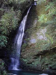
After leaving the temple and following the Nigorigo river up past a waterfall
through a canopied forest of cedar and white birch
the path opens out to a open clearing with a symbolic bell used by the many (followers of religion) who frequent this path as part of their belief in the sacred nature of the mountain.
From this opening, there is a clear view of the mountain range to the north, and in particular Jounen (常念) and Yarigatake (槍ヶ岳). Not far from this point the vegetation changes to juniper trees which are more adapted to the harsh weather conditions. Junipers produce a lovely waxy red acorn with a succulent red seed in every segment. Not only is this used in French cuisine and local sake brewing, but the birds like it too. I saw quite a few birds racing through the sky with the bright red acorn in their beaks.
The vegetation on Ontake is of interest to many as it is famed as a medicinal mountain with specialised species of plants that are unique to the mountain.
Ontake is still an active volcano, and the view as the path steers around the low lying juniper and up into boulders and rocks revealing a jutting peak that is distinctly volcanic in appearance. The valley formed by this peak and the peak where Go No Ike Goya sits creates a cold wind tunnel, and ice can form on the path in the early morning, even in Autumn.
The last 300 metres up to the Go No Ike is pure rubble, and very close to the edge of the cliff. It is advisable to take this section with caution. At Hida no Chojo summit, you are immediately rewarded with views over San no Ike and the spectacular view over the Alps. The ominous looking peak directly in front of Go no Ike resthouse is the Marishiten summit (摩利支天山).
Past the Go no Ike resthouse, the trail continues towards the summit via different routes. The most direct route (90 minutes) is the Sai no Kawara (サイの河原) route which starts out as a steep hike up the rocky cliff which has a 15 minute detour at the top to the summit of Marishiten at 2959m. From this peak, it is a short 10 minute descent to the valley below past Sai no Kawara Hinan Goya (河原非難小屋) and then past the dilapidated and seemingly abandoned lodge near the emerald waters of Ni No Ike and Ichi no Ike.
After passing the two lakes, there is a large torii (temple gate) where it is advisable to take a moment to catch your breath before embarking on the final and near vertical ascent to Kengamine summit (剣が峰) which might take anywhere between 10 to 35 minutes depending on your fitness. At the top there is a set of stairs which lead to the temple complex at the summit.
The top was quite crowded when I got there (the presence of the Ontake ropeway from 1570m to 2150m on one of the other trails makes the peak more accessible), with at least 50 “hikers” all taking their commemorative photos in front of the altitude marker.
There is a compass at the top with the names of all the surrounding peaks clearly marked. Mt Fuji is unmistakeably visible between two minor peaks in the distance and the view from this particular peak reinforces the impression that Mt Fuji is more beautiful from afar rather than from its peak.
For a different experience, walk behind the temple and enjoy the view from there. It is particularly interesting as you sit (or stand) on a precarious pile of rocks rising about 50m from the hissing valley below which is still quite active and gives of plumes of steam with a distinctly sulphurous smell.
After enjoying the amazing views from the top it was time to head back down for a soak in Nigorigo onsen at the base.


