Hakkoda is located in the Aomori Prefecture, south of Aomori city about 70 minutes by car, and is part of the Towada Hachimantai National Park. There are a numer of buses that will take you from Aomori city to Sukayu, ask at the tourist information centre at the Aomori train station for details.
Hakkoda translates as 'many peaks' and there are a number of routes possible from the same trail head. The visitor information centre located right next to the Sukayu onsen has a useful 3D model that lights up each of the available trails. The centre also provides detailed information regarding the time allocations for each trail from a variety of points along the path.
The trail head is located across the road from the visitors centre.
Wet weather gear is essential if you are thinking of climbing in the Hakkoda region. The range is well known as being the site where almost an entire regiment of fit, healthy and well trained Japanese military men died during a training exercise to prepare for a possible battle with Russia in 1902. Of the 210 sent for training, only 13 lived to tell the tale.
Having said that, Mount O is a relatively easy mountain to climb. The hike begins in a densely forested area with only a moderate uphill gradient.

This path opens out to a wonderful view at a sulphuric rock encased stream, where very little vegetation survives. This lack of tall trees enables a great view across to the neighbouring mountains in the Hakkoda.

The vegetation that does survive in this sulphuric region is very interesting, so this area is worth looking at on the macro and micro levels.

The climb only really begins after the mountain well, where there is a small wooden structure to enable hikers to fill their bottles or take a rest and drink. The first mountain hut is also signposted at this point.

The surrounding marshlands are also full of interesting vegetation.

In the marshland area, there is a pond named the mirror pond. It is supposed to be a wonderful emerald green marvel that reflects the sky and the person viewing the pond. For me it was a misty event.

After crossing the marshlands where the well sits, the path leads into a barren expanse of volcanic boulders held into place with dense wire. It was at this point in the hike, when the day began sunny as summer, that the wind came in icy cold and rain bucketted down.

The summit held a small shrine and a sign worn away from weather, it was really raining hard, so I didn't stop to long to look around. I could, however, reflect on the the fate of the lost regiment and understand how such a situation could have occurred.

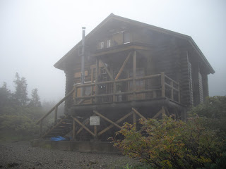
Thankfully, there is a very pleasant and well situated second mountain hut just over the peak.

A few groups were already sheltering there when I arrived, and I was quickly offered some hot miso soup by a kindly group of older and well prepared hikers.

The rain eased, and settled into a drizzle, at which point I headed back down the trail. I enjoyed traversing an interesting mix of alpine, arid volcanic rock and deep pools in the grassed marshland areas. I also liked the deep green along the trail.

The path down had a staircase that felt like a cartoon it went on so long and across all array of terrain. I felt glad for it, above the muddy mountain floor.

Walking straigh off the mountain into the Sukayu onsen that has been in operation for more than 300 years, is a truly memorable experience. Despite the weather and the lack of visibility from the peak, I truly enjoyed this hike!
No comments:
Post a Comment